Plots in Las Palmas - buy, sell or rent easily
Find plots by category in Las Palmas (Province)

Plots for sale with most wanted features
- Urban 12
- Developable 10
- Undevelopable 15
- De propietarios 37
- Urban 57
- Developable 19
- Undevelopable 16
Bank-owned land in Las Palmas


Latest publications of land and houses for sale in Las Palmas (Province)


Where to buy land in Las Palmas
The cheapest land in the province of Las Palmas is in Telde, with a minimum value of €1.90/m²; Tuineje, with €2/m²; Firgas, with €2.70/m²; Teguise, with €2.80/m²; and Tecén, with €2.90/m². These figures are due to the scarcity of urban land available for residential use and the high demand for rustic properties for sale.
The average price of urban land in Las Palmas is over €200/m², which makes it one of the highest in the country. The developable plots are grouped in the main cities of the province, so they experience a situation like that of the urban area. The most expensive land for sale is in Ingenio, Arrecife, Agüimes, Telde and Las Palmas de Gran Canaria.
The Canary Islands, looking outside
The Canary Islands, in general, depend on imports from abroad to supply the population, a fact that began to occur with the rise of tourism in the mid-20th century. From then on, the islands began to become tertiary. Currently, its gross domestic product practically depends on this sector (services and public), followed far behind by construction, industry, and agriculture.
One of the advantages of the Canary Islands for the development of the agricultural sector is the natural and climatic conditions (microclimates) since they allow various quality products to be grown throughout the year.
The province of Las Palmas, with an area of 4,066 km² and more than 1,100,000 inhabitants, is the most populated of the Canary Islands. It is made up of the eastern islands of Gran Canaria, Fuerteventura, and Lanzarote; all of them declared Biosphere Reserves by UNESCO.
The capital is in Las Palmas de Gran Canaria (Isla de Gran Canaria), the most populous city in the entire province.
Gran Canaria is committed to sustainability
This Island is characterized by its biodiversity and nature. It is in the centre of the Canary archipelago, it has an area of 1,560 km², the third in terms of the size of the islands. Its economy is based, as in the rest, on tourism and related services, although it wants to recover the agricultural sector to become self-sufficient.
Tourist activity has led to the urbanization of the largest and most visited cities. The urban areas of the capital's metropolitan area are the most densely populated and are where services, industry and commerce are concentrated. There, the value of residential and developable land is high due to its scarcity and strong demand. The rest of the cities are scattered in more rural and quiet areas, which complement tourism with other initiatives linked to nature.
The primary sector fights for its survival
The primary sector is irrelevant to the island economy, contributing just over 1% of GDP. It is very weakened (due to the abandonment of the activity, competition from other more powerful markets, the prices of imported products and the increase in the population) and it wants to recover its activity; To this end, the cultivation and consumption of indigenous products are encouraged, to obtain sustainable production that provides food for the island's self-sufficiency.
The agricultural area of the Island has remained stable in recent years (it occupies around 20% of the territory), but the cultivated agricultural area has decreased (by more than 1,500 hectares) and is less than the uncultivated area.
The administration supports this sector through the experimental agricultural farm, the analysis laboratory, and the improvement of rural infrastructures.
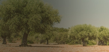
Today, the outstanding crops are bananas and tomatoes. Fruit, vegetables, and potatoes are also grown. Flowers and plants are also grown, a booming activity on the island.
The cattle herd has decreased in recent years. It is made up of cattle, goats, sheep, pigs, poultry, and rabbits. Milk production stands out, followed by meat, chicken eggs and honey.
The natural resources of the Island
The wooded surface of the Island has decreased over time, but its recovery, both natural and through repopulation, has given rise to around 13,000 hectares of Canarian pine forests. In addition, there are the palm groves formed by the Canarian palm and the date palm. Although thickets predominate in the area (broom, reedbeds and brambles), there are also parts where the laurel forest and the Drago grow.
The climatic characteristics of the Island are ideal for taking advantage of the energy of nature, such as the sun, the wind, and the sea. Through renewable energies, solar energy can be produced, just as desalination plants convert water into drinking water for human consumption and agriculture, while the potential of wind energy provides the rest, as, in Arinaga, where find the largest wind farm in Spain.
in Fuerteventura, rural lands are waiting for you
The territory of Fuerteventura occupies more than 165,000 hectares, it is the second in terms of its extension. Its climate is subtropical and arid, with little rainfall and an average annual temperature of 20ºC.
As in the rest of the islands, tourism is the engine of the economy and like its neighbour Lanzarote, this activity is carried out sustainably.
On the island, we find different types of terrain. Residential areas are grouped around urban areas, where urban and developable land is found. The rustic ones are classified according to their use, such as the rustic ones with the dominant natural value of concentrated rural settlements, which occupy a large area of the island. In some coastal areas, you can also find the ones with the highest natural value. In the centre, there are those of productive aptitude. While in other scattered areas we find the common.
Promoting agricultural land use
The agricultural system occupies more than 9,000 hectares, more than 1,000 are cultivated land, while more than 7,000 are uncultivated and the rest are pasture (a residual amount). The rest of the surfaces occupy more than 150,000.
The council has organized a farmland bank to facilitate its lease or sale. This is intended to increase its value and stop the loss of useful agricultural areas, to promote the agricultural use of the land.
Most of the crops are mainly rainfed, due to its dry climate with little rainfall and its arid lands, although some are also irrigated. To take advantage of natural water resources, farmers build gavias, nateros, chains and water wheels to irrigate their fields.
The most fertile valleys are those of Betancuria, Santa Inés, La Oliva, Antigua, Tetir, Río de Palmas, Pájara and Tuineje.
The island cultivates tropical pineapple, olive groves, vineyards, cereals, legumes, fruit trees, tomatoes, potatoes, and bananas. We also find grasslands. As well as some typical horticultural products of these latitudes. In addition, the cultivation of ornamental plants is also carried out.
The orchards are the spaces that occupy the most surface area since they include the fallow area; followed by fruit trees, vines and tomatoes.
As for livestock, goats stand out, as in recent years their infrastructure and facilities have greatly improved, as well as their production, specially dedicated to Majorero cheese, is of great quality and international prestige.
Lanzarote, the sustainable island
With an area of 845.94 km², it is the fourth largest island in the Canary archipelago.
Its climate is mild, with little rain and sunshine practically all year round, with an average temperature of 21º.
It is a sustainable tourist destination since its development has been produced respecting its environment.
Since the arrival of the first tourists, the first water desalination plant in Europe was installed on the island. Likewise, wind energy was adapted to the Island. It was one of the first places in Spain to be declared a Biosphere Reserve in its entirety.
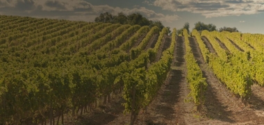
In its landscape, among volcanic reliefs, it is surprising to find vine crops. In the Geria area, farmers have been able to adapt agriculture to the climate and geology of the place, using volcanic rock and stone walls to create a vineyard that has produced high-quality wines, with the internationally recognized Malvasia Volcanic Denomination of Origin.
Other crops that we can find on the Island are fig-trees, moral trees, and palm trees. Among its fruit and vegetable products, we find chard, aloe, peas, sweet potatoes, zucchini, pumpkin, onion, asparagus, strawberries, chickpeas, lettuce, lentils, melon, millet, potato, papaya, tropical pineapple, banana, watermelon and tomato.
As for its livestock products, the following stand out: goat meat, pork meat, rabbit meat, sheep meat, beef, chicken eggs and cheese.
In conclusion, in the province of Las Palmas, which groups these three islands, we observe both differences and similarities. Due to its climatic conditions and volcanic soils, the crops are similar. Likewise, thanks to their landscapes they are the destination of many tourists throughout the year. Each of them has a particular idiosyncrasy, but all of them are aware of respect for the environment and what it represents for the islands.